WHAT'S NEW IN TERRITORY MANAGER?
Find out here about the latest new features in the Territory Manager application: Spring '26, Fall '25, Summer '25, Spring '24, Fall '24, Spring '24, Fall '23, Summer '23, Spring '23, Fall 2022, Summer 2022, Spring 2022, Summer 2021, Winter 2021, Summer 2020, Winter 2019, version 6 et version 5.
Spring '26 version

Publishing date: 17/02/2026
Various improvements
- Added features to the API (function to obtain the geometry of a set of postal codes, option to force the display mode of sectors, option to force the naming of sectors according to a provided rule)
- Addition of 2025 Q3 administrative data (postcodes, cities, etc.)
- Fixing slow display times in Chrome
- Fixed a bug where visit frequencies were not being taken into account in Optimal Team Size mode
- Fixed a bug related to adding an indicator to an existing simulation
Fall '25-2 version

Publishing date: 06/11/2025
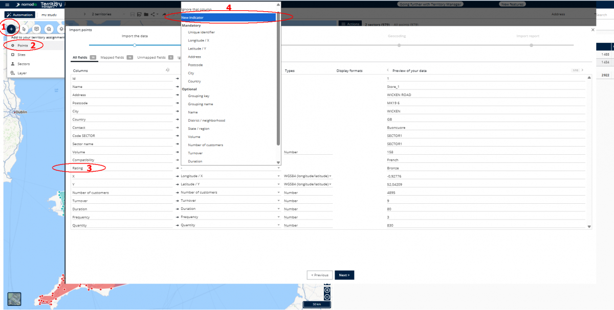
Adding indicators after creating a simulation
It can happen that, after creating a study, you realize that you need an additional indicator that was initially overlooked.
This is now possible by selecting New indicator in the simulation data update function (the "+" button in the map).

Various improvements
- Possibility to add a site through the Actions menu even when there are no sites yet in the simulation.
- The Postal boundaries display layer was added to the map
- New button to invert the order of simulations when comparing them.
- Fixed a bug that caused notifications for the next Territory Manager update to no longer be displayed.
Fall '25 version
Publishing date: 09/10/2025
Main new features
New automatic territory assignment mode: Right team size
Determine the right team size to complete all the planned work.
On a daily basis, load your deliveries for the day, and determine how many delivery people you will need to deliver everything, taking into account the delivery people's working time and the location of the warehouse.
When planning for the year, build a new team of salespeople or technicians to carry out all the appointments for the year, based on your objectives for frequency and duration of visits.
In statistical forecasting, load observed data, calculate a core permanent staff with Territory Manager to carry out the work. Draw from it a team of subcontractors to manage contingencies (illness, leave, exceptional overload, etc.)
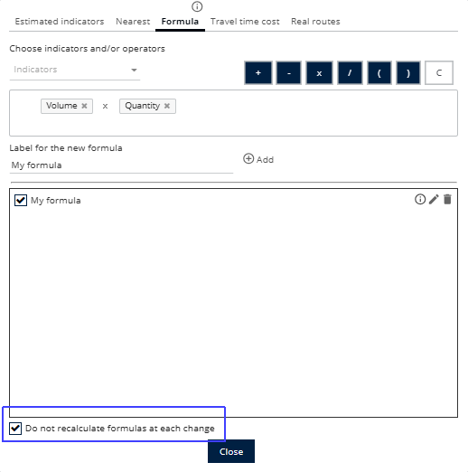
Improve Territory Manager's responsiveness by putting formula calculations in manual mode
A new mode for pausing formula calculations allows you to avoid long waiting times when you have many formulas and many points.
Put formulas in manual mode, edit your slices without long waits for the table to redisplay, then update your formula fields.

API linked to a Territory Manager user account
New functions are available in order to connect to a specific user account.
Once connected, new functions can be used to retrieve existing studies and simulations, or to save loaded data to an existing study of the user.
Various improvements
- District field for geocoding (to specify the address in some countries)
- Ability to modify the number of working hours per day directly in the configuration of Real routes (Premium +)
- Brightness, contrast and transparency adjustment now also applies to Sites and Aadministrative level tabs
- Exporting data to Excel now enables the Export input columns values option in Standard mode.
Summer '25 version

Publishing date: 08/07/2025
Main new features
Various improvements
- Site display in simulation comparisons
- Exporting sector and administrative level colors to Excel format
- Importing sector colors when updating sites or sectors
- Cancelling administrative level renaming
- Simulation sharing message: storing the fact that the notification has been viewed independently of the browser
- Simulation sharing: sending an email to the user receiving the share
- Locking the launch of an automatic sectorization if one is already in progress
- Disabling the warning about the risk of losing changes when the server connection is lost
- Exporting an image uses the display of the active tab (when using administrative levels)
