-
From the Territory assignment page, click on
-
Select your preferred territory assignment method
Method Pre-requirements Description Balancing the entities
Import points or
Import geographic entities.Balances territories against one or more indicators.
As close as possible
Import points or import geographical entities and
Import sites.Assigns entities to the nearest site according to constraints.
Balancing the sites
Import points or import geographical entities and
Import sites.Balance by taking sites into account.
- Click on
| Filter on | Description |
|---|---|
|
No filtering |
Default value. Territory assignment is performed on all points or geographical entities. |
|
Selection |
Territory assignment is performed on all the points or geographical entities selected in the table or map. |
|
Visible territories |
Territory assignment is based on all sectors declared as visible in the table. |
|
Only those assigned |
Territory assignment is based on all the points or geographical entities assigned to a territory |
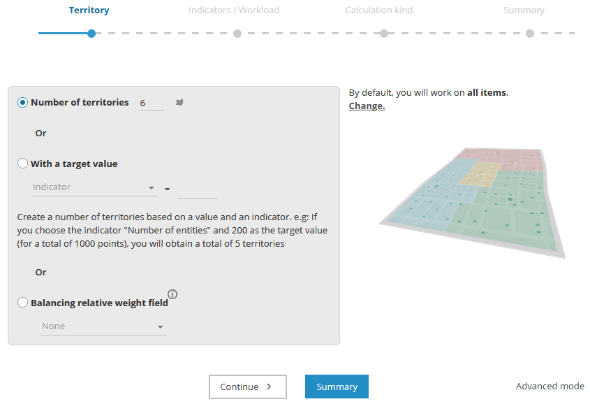
| Number of territories | Action |
|---|---|
|
Number of territories |
Equitably distributes the number of points or geographical entities according to an imposed number of territories. |
|
With a target value |
Creates a number of territories based on a value or indicator |
|
Balancing weighting field |
The target value to be achieved for each territory will be proportional to the value of the weighting field indicated. |
| Balancing territories according to | Parameters |
|---|---|
|
Balance by indicator [Indicator] |
Number of entities Up to twelve parameters can be combined. |
|
Territory assignment priority |
Five levels between compactness and balance. |
| Parameters | Description |
|---|---|
|
Limit |
Limit in minutes. |
|
Capacity |
Match capacities and volumes. |
|
Compatibilities |
Apply a compatibility criterion. |
| Parameters | Description |
|---|---|
|
Territories weighting |
Associate with a weighting field. |
|
Number of sub-territories |
Force the number of territories per site with the value of an indicator carried by each site. |
|
Compatibilities |
Apply a compatibility criterion. |
| Route according to | Parameters |
|---|---|
|
Type of route calculation |
Fastest (default) |
| Parameter (or setting) name | Description |
|---|---|
|
As the crow flies (calculation type) |
Searching as the crow flies results in a territory assignment without any reference to the road network. It is faster, and less precise, however it provides a rough idea of the simulation. |
|
Apply by territory* |
Associated to Allow editing. Selecting this option allows you to choose whether a given modification is applied by territory, or globally. When activated, the same proportion of candidate points in all territories will be subject to a change in assignment. If the option is not activated, modifications will be heterogeneous, depending on the territory. |
|
Restrict modification |
This option allows you to retain some of the previous assignment, allowing only
X% of points on the map to change territory. |
|
Capacity / Volume (constraint)* or Set up volume and capacity correspondences |
This constraint sets up a relation between a quantity assigned to an object and a capacity assigned to a site for the assignment. |
|
Workload |
Applies balancing based on an estimated journey time and on an indicator representing visit time. The journey time is the time from the first to the last visit. The journey between sites (or barycentres) and the first visit, and the journey between the last visit and the site (or barycentre) are not taken into account. |
|
Compatibility |
The application will assign to each object the site that is nearest and has the same compatibility value as the object. This indicator must be present on sites and objects. |
|
Grouping criterion* |
This option allows you to group a series of points having a common value stored in a field that renders them unsplittable
in the event of an assignment. |
|
Balance territories* |
Depending on the number of points and/or depending on indicators present: |
|
Exclude unassigned |
Unassigned objects will not be included in the territory assignment proposed. |
|
Visit frequency* |
Provides estimated journey time to weight with the number of visits made to the point in the period analysed (week, month, year, etc.). This can be linked to the Journey time indicator and edited when estimating this indicator. |
|
Indicators |
Enables balancing on the territory assignment as a function of an indicator. |
|
Shortest (calculation type) |
Searching on shortest, via the road network, results in more compact territories, because the distances travelled are minimised |
|
Fastest (calculation type) |
Searching on fastest, via the road network, results in territories that are less geographically compact, but more accessible. |
|
Limit in minutes |
A search radius around sites in terms of duration or distance can be defined. Points lying outside the search limits will
not be assigned. |
|
Number of points |
Indicates the number of points used when calculating the estimation. |
|
Geographic points / zones |
Select one of three options: |
|
Weighting |
The target value to be reached for each territory will be proportional to the value of the weighting indicator chosen. |
|
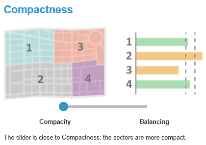
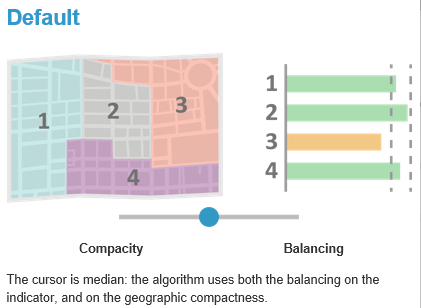
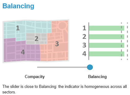
Territory assignment priority* |
Associated to Balance territories. Defines a possible weighting in relation to the perfect balance between the different territories. When territory assignment
is applied, the algorithm takes into account the statistical rule used (equal territories according to X indicators) as well
as the territory’s geography (compact territory, without holes). The closer the cursor is to Balanced the greater the respect for the statistical rule will be. The closer the cursor is to Compactness the more compact the territory will be. |
|
Respect all criteria* |
If this is checked, when a point has several compatibilities (separated by semicolons ;) it will only be assignable to the site that also has all these compatibilities (separated by semi-colons ;). |
|
Restrict modifications |
Allows you to retain some of the previous assignments, allowing only X% of the points on the map to change territory. |
|
Territory assignment for visible territories only |
Only takes into account territories that are visible on the map (hidden territories will remain unchanged). If no territory is hidden, this option is not available. This makes it possible to lock certain territories so they are not taken into account in an automatic territory assignment. |
|
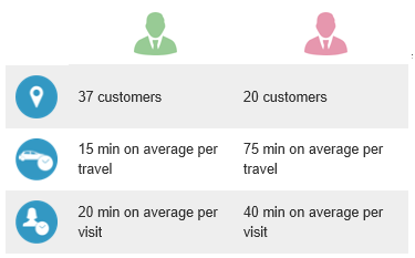
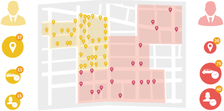
Workload |
This option results in a territory assignment balanced on an estimation of journey time. If combined with the Visit time indicator, you will obtain a balancing on workload. |
For example: despite the differences, these 2 territories have the same workload.
|
Calculation type |
The calculation type (fastest, shortest, as the crow flies) allows you to strategically shape the resulting territories. |
|
Number of territories |
When the number of territories to generate is not a limiting criterion for the user, Territory Manager can be requested to
suggest a number of territories to generate to obtain a balanced territory assignment. The user needs to define an indicator,
the value of which they want to attain by territory, as for example: balance on territory potential, with all territories
having a value of up to 500,000. |
|
Territory names |
Following an automated territory assignment, the names of the previous territories are retained, if 50% of their points have remained within this same territory. Otherwise a new name is automatically assigned |
|
Points with the same coordinates |
Points which have the same X,Y coordinates (same address) will have their indicators concatenated. These will be treated as a single and same point attributed to a territory, which could result in imbalances. |
|
Estimated journey time |
Estimation of the time spent on the road to visit all points within a territory. |
|
Visit time |
The visit time corresponds to a visit duration assigned to each point by the user. This is entered as an indicator (duration). Combined with the Journey time indicator, we obtain a balancing on workload. If a client has an estimated visit time of 20 minutes and is visited 5 times, this represents a total journey time of 1 hour and 40 minutes on the global territory assignment. The visit times are multiplied by the rounded frequency: for example 1’29 = 1 minute (rounded down to the lower value). If this visit time is multiplied by a frequency of 5 (for example) we will lose 29 seconds x 5. The impacts are nonetheless quite marginal. |
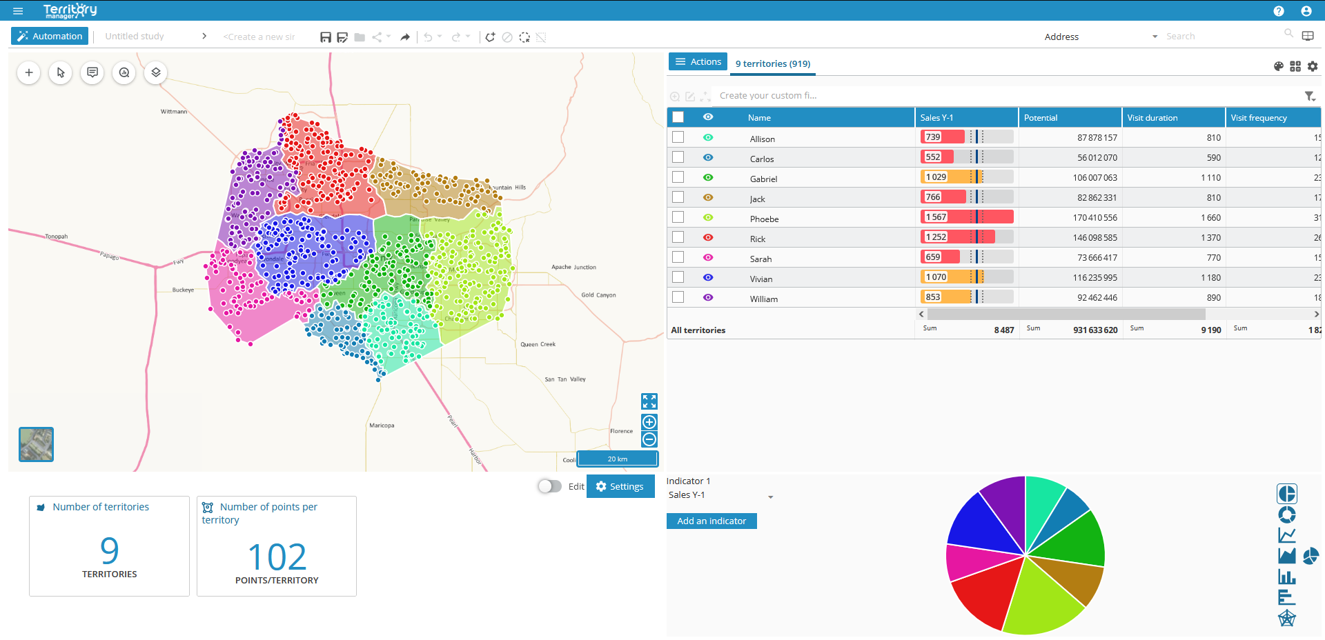
The interface in the Territory assignment page of Territory Manager is made up of four main panes: map, table, graphs, key indicators (KPI), with a toolbar and a main menu above.
Accessible via the menu icon 
|
Home page |
|
|
New Study |
|
|
List of studies |
|
|
Saved simulations |
|
|
Compare current simulation with… |
|
|
Save |
|
|
Save a copy |
|
|
Edit |
|
|
Sharing link |
|
|
Share a copy |
|
|
Export |
|


Once the initial territory assignment has been performed, you can add to it using the Import sites, resources icon 
- Geographic objects (points or polygons)
- Sites
- Some territories
- Layers
| Additions | Pre-requirements | Import result |
|---|---|---|
|
Points |
Automatic territory assignment on points |
These objects will be added to those already present in the territory assignment page. |
|
Entities |
Automatic territory assignment on geographic zones |
|
|
Sites |
Automatic territory assignment on points or |
Sites integrated: |
|
territories |
Import of sites |
Several territories can be associated with a single site. Territory assignment then creates as many sub-territories per site. The color of these sub-territories is chosen according to the color of the site. |
|
Layer |
Automatic territory assignment on points or |
Layer objects are not selectable. See chapter Manage layers. |
See Import data / Pre-requirements for information on file and data formats.


