Territory Manager handles several file formats: XLS, .XLSX, .TXT, KML, KMZ (layers only), Google Sheets and OneDrive.
Territory Manager is optimized for .XLSX formats (notably with utilisation of date as indicator fields) with a volume less than or equal to 100,000 lines.
The file is made up of the following fields:
| Import type | File content | Mandatory fields | Optional fields |
|---|---|---|---|
|
Initial import (Assign territories to the points) |
Points |
Unique identifier |
Indicator Grouping key |
|
Additional points |
|||
|
Initial import (Assign territories to the geographic zones) |
Geographic entities |
Unique identifier |
Indicator |
|
Additional geographic entities |
|||
|
Sites |
Sites (max 250 lines) |
Unique identifier |
Indicator |
|
Territories |
Territories affiliated to sites (several territories can be associated to the same site) |
Site identifier |
Indicator |
|
Layers (Carbon copy, Tracing paper, Replica…) |
Points (max 100,000 lines) |
Unique Identifier Coordinates (Longitude/X, Latitude/Y) |
Indicator |
| Fields | Format | Comments |
|---|---|---|
|
Address |
Alphanumeric / string |
Information relating to point location |
|
Grouping key |
Alphanumeric / string |
Displays a previous territory assignment operation. Objects are grouped in relation to this key. |
|
Post Code |
Alphanumeric / string |
Information relating to point location |
|
Color |
Hexadecimal from #000000 to #ffffff (html) |
For territories and sites. |
|
Site identifier |
Alphanumeric / string |
Identical to the grouping key if using territory assignment with sites. |
|
Unique identifier |
Alphanumeric / string |
Unique identifier of the point or geographical entity. |
|
Unique identifier - Geographical entity |
Post code |
|
|
Indicator |
Alphanumeric / string |
Data item to take into account for balancing secctors (eg, turnover, number of fire hydrants, number of clients to visit…) |
|
Longitude / X |
WGS84 EPSG 4326 |
Localisation information for points and sites |
|
Latitude / Y |
||
|
Name |
Alphanumeric / string |
Name of objects, points or geographic entities. |
|
Grouping name |
Alphanumeric / string |
Allows you to display on the map a territory assignment previously carried out / a site survey, by assigning a Territory name to each line. |
|
Country |
Alphanumeric |
ISO 3166-1 alpha-2 (2-character country code). |
|
Town |
Alphanumeric / string |
Information relating to point location. |
| Territory assignment type | Action type |
|---|---|
|
Assign territories to the points |
Import points |
|
Assign territories to the geographic zones |
Import geographic entities |
-
Click on the box with dotted borders as indicated in the illustration, and
select the file to import
You can also drag-and-drop the file to the inside of this box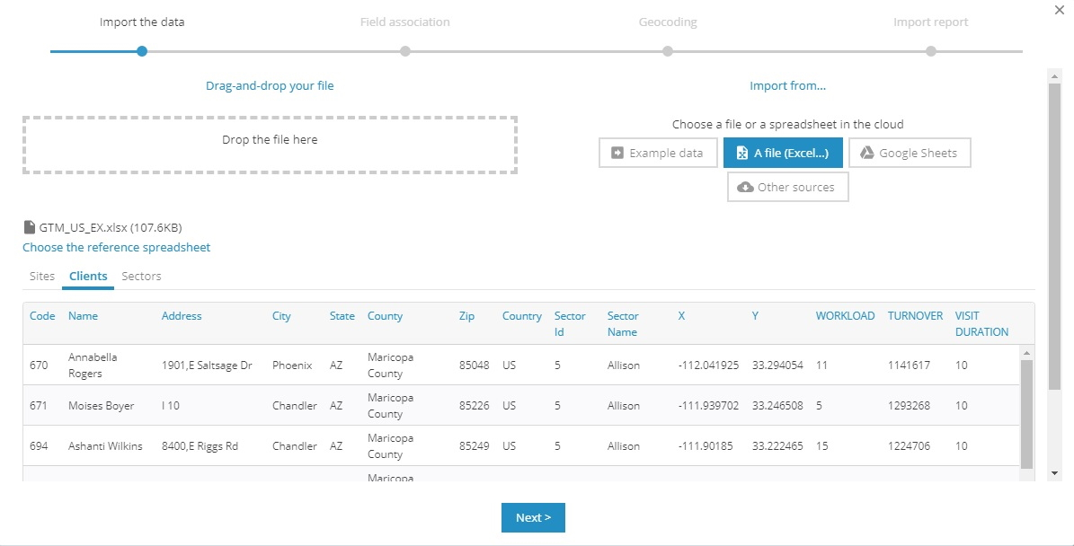
-
Click on
If the file to import is in Excel format, and has several tabs, you can select which tab(s) to import. A preview of the file is provided.
For the around sites territory assignment type, you will need to first import the points or geographic zones and then import the sites from the Territory assignement page.
